
by Rob | Jun 20, 2020 | Press release
Over the past decade, the process of creating accurate 3D maps and models from drone photos has come a long way. Drone capture capabilities and photogrammetry processing software and services have improved in cost and efficiency to a point where 3D digital twins are a...
by Rob | May 4, 2020 | Testimonials
After conducting numerous missions of trial areas, as well as comparisons to physical GPS/laser scanning surveys I have observed the following accuracies: Camera accuracy MAX 30mm (as reported in agisoft) PPK accuracy AVG 12mm (compared to RTK points) GCP accuracy AVG...
by Rob | May 4, 2020 | Testimonials
The experts at Klau Geomatics have really revolutionized precision drone data collection with their PPK unit. The system allows us to outfit our existing equipment with accurate camera positioning. –Matt Mercurio; Spatial Analytix, USA
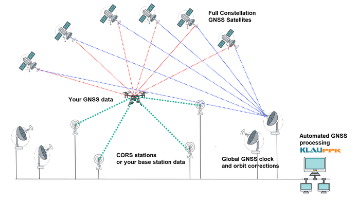
by Rob | Mar 10, 2020 | Press release
Post Processed Kinematic (PPK) has been the positioning tech of choice for the past few years. Drone operators have seen the advantages of PPK over RTK in the quest increased efficiency and accuracy with less dependence on Ground Control Points (GCPs). Now Precise...
by Rob | Feb 10, 2020 | Testimonials
We conducted a ground-based site surveying by qualified surveyors with survey grade total stations to evaluate the accuracy of the KlauPPK system. Then with a Klau calibrated X4s camera on a DJI Inspire2 drone we captured aerial data at a 10mm ground sampling...
