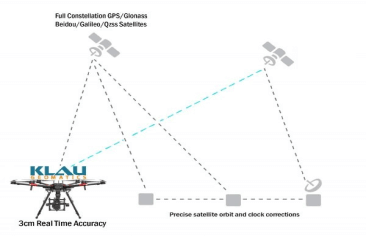
Klau Geomatics, established a leader in UAV PPK solutions, has released another breakthrough in survey technology for drones and manned aerial mapping: Real-Time PPP (Precise Point Positioning), enabling 3 to 5cm initial positioning accuracy, anywhere in the world, without any base station data or network corrections.
Just fly your drone. Fly any distance, anywhere. You can navigate with real-time cm level positioning or geotag your mapping photos and Lidar data.
You don’t need to think about setting up a base station, finding quality CORS data or setting up an RTK radio link. You don’t need to be in the range of a CORS station, you can fly autonomously, in remote areas, long corridors, unlimited range, it just works, giving you centimeter-level accuracy, anywhere.
Now, with this latest satellite-based positioning technology, 3 to 5cm accuracy can be achieved, anywhere in the world, with no base station. The Klau Geomatics hardware/software system is now the simplest, most convenient and accurate positioning system for UAVs and manned aircraft. The bundled solution enables accurate positioning in any published or custom coordinate system and datum.
This technology is very applicable to surveying, mapping, navigation and particularly the emerging drone inspection industry, starting to realize that absolute accuracy is essential to analyze change over time in 3D assets.
A BVLOS parcel delivery drone can now travel across a country and arrive exactly on it’s landing pad. No range limitations, no base station requirements or radio links. Highly accurate autonomous flight.
Large scale enterprise drone companies can deploy their fleet of operators with a simple, mechanical workflow to capture accurate, repeatable data, without the complications of the survey world; of RTK radio links and network connections or logging base station data within the range of each of their many projects. Now they have a simple consistent operation that just works, every time, every location.
“Just as Klau Geomatics led the industry from RTK and GCPs to PPK, we now lead the charge to PPP as the next technology for simple, accurate drone operations,” says Rob Klau, Director of Klau Geomatics.