Klau Geomatics Releases Hybrid PPK PPP Processing
by Rob | Mar 10, 2020 | Press release

Post Processed Kinematic (PPK) has been the positioning tech of choice for the past few years. Drone operators have seen the advantages of PPK over RTK in the quest increased efficiency and accuracy with less dependence on Ground Control Points (GCPs). Now Precise Point Positioning (PPP) is coming into focus as a way to achieve high accuracy, with its own unique characteristics, advantages and disadvantages. Klau Geomatics has now released sophisticated processing that brings PPP and PPK together in an optimised highly accurate solution that works anywhere without any base station data.
PPP is not that new, it has been around for a couple of decades. Only recently has the technology reached an accuracy level suitable for drone surveying, mapping and inspection applications.
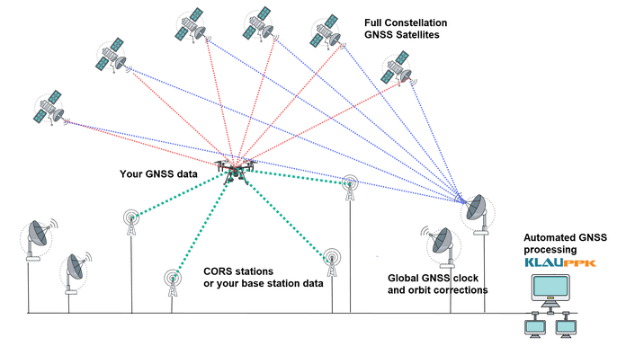
PPP uses precise satellite clock and orbit corrections, determined from ground tracking stations around the globe. It does not require any base station data or radio links to achieve high accuracy.
Traditionally it took 14 days for the clock and orbit correction data to be available. Klau Geomatics has created a revolutionary new hybrid PPK/PPP processing service with access to the final clock and orbit corrections just minutes after the mission.
The key value proposition of Klau Geomatics PPP/PPK is that it is autonomous, it works anywhere, requires no other user inputs, such as base station data and radio/GSM links, either soon after the mission in post processing (like PPK) or real time (like RTK). It just works on its own to achieve this very high accuracy, regardless of the location of the user. Accurate datum and tectonic plate motion corrections, specific to different countries and regions, are automatically applied to deliver the most accurate solutions.
Real time PPP is valuable to those requiring precise real time navigation. Innovative specialist drone solutions carrying cameras and sensors may require cm level accuracy for drone navigation or precise real time sensor data integration. High precision GNSS data fed into an INS (Inertial Navigation System) will enable more accurate Kalman filtering for precise live sensor orientation.
Drone delivery is another application requiring accurate positioning, to travel long distances (beyond the range of RTK and other differential systems) to land on a small target.
Near Real Time PPP is more applicable to inspection, surveying and mapping. The drone inspection industry now sees the need for absolute accuracy to analyse change over time on 3D assets. Klau Geomatics NRT technology makes that easy and repeatable, anywhere. The precise corrections are applied to data from custom-tuned KlauPPK GNSS receivers in the KlauPPK post processing software to enable centimetre level accuracy anywhere in the world without the need for RTK, CORS or local base station data.
Hybrid Processing. In some areas such as US, Europe, Japan, New Zealand and Australia, the achievable accuracy is even more refined thanks to the Klau Geomatics hybrid terrestrial multi station and PPP algorithm. Data from as many as 15 reliable long-range CORS stations, where available, are applied to the processing. The enhanced PPP solution achieves 1-3cm XYZ absolute accuracy in many parts of the world.

The same KlauPPK software workflow applies, to synchronise camera events, apply lever arm corrections, manage coordinate systems and geoids, apply site localisations, capture ground points, and so on. Instead of choosing a base station, which should be within 20 miles of the site, or setting up an RTK radio link, users with an active KlauPPK subscription can process a high accuracy trajectory, anywhere, without any other inputs. The annual subscription enables unlimited processing of data from KlauPPK hardware.
Enterprise drone operations can now deploy multiple crews anywhere in the world and apply one simple consistent workflow to the operation without concern for the ‘survey’ aspects of sourcing and managing base station data, if it is available at all.
This is powerful new technology and will be a differentiator for those at the leading edge of UAV solutions.
