
NEWS
-
Hear the latest from Klau Geomatics
-
Subscribe on the Contact page and we’ll keep you up to date
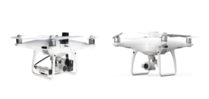
Phantom 4 Pro or RTK?
Over the past year or more the Phantom 4 RTK has become the popular entry-level mapping drone. But now with its older brother, the Phantom 4 Pro, back on the block, it’s worth taking a good look at how these drones go head to head on surveying and mapping. To ...
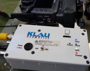
KlauPPK: Versatile, with More Data, More Accuracy, More Options
Klau Geomatics, manufacturer of the KlauPPK system, has released a new hardware system that offers increased versatility in accurate positioning for UAV and manned aerial mapping. KlauPPK offers more versatility; the modular design can move between drones, cameras and modes of operation, PPK, PPP real time and PPP post processed ...
The Business Model for UAS – Geosyntec Consultants
Leveraging UAS technology across surveying and engineering sectors is demanding. The expectations of accuracy and accountability require the best in expertise, methodology, and equipment. Using the latest UAS photogrammetric hardware and software, surveyors are now capturing 10s of millions of survey measurements on the ground, where they would previously have ...
The Rise of Manned Aerial Mapping
UAVs have brought photogrammetry back as a bread and butter tool for surveying. They’ve put mapping back on the map. But often we see large ambitious UAV projects undertaken, to capture long stretches of highway or vast expanses of detailed mapping, taking weeks of UAV survey crew time, hundreds of ...
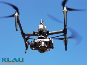
Sony Camera Payload for DJI drones from Klau Geomatics
With the end of the DJI X4s camera, drone operators have been looking for a quality mapping camera solution for the Inspire 2 and M200/M210/M210V2 drones. Klau Geomatics has released a Sony camera/PPK payload to offer even better results from these drones. This enables more effective and accurate mapping and ...
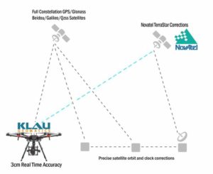
Klau Geomatics releases High Accuracy Real-Time Positioning Technology
Klau Geomatics has released Real-Time Precise Point Positioning (PPP) for aerial mapping and drone positioning that enables 3 to 5 cm initial positioning accuracy, anywhere in the world, without any base station data or network corrections. With this, you Just need to fly your drone at any distance, anywhere. The ...
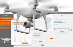
KlauPPK software for the Phantom4 RTK
Klau Geomatics, industry leader in PPK hardware and post-processing software, announced today its new PPK software for the DJI Phantom4 RTK drone. The software enables professional users to achieve the most accurate and reliable results with their P4RTK drone without running it in RTK mode. RTK requires continuous communication between ...
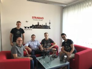
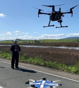
STRABAG, one of the largest construction companies in Europe, adopts KLAUPPK high precision drone surveying technology
STRABAG is a European tech company for construction services with about 73.000 employees worldwide. In early August, the first KlauPPK system was delivered to STRABAG‘s department “Digital Object Scanning and Drones”, by Videographics Ingenieurgesellschaft mbH as a local representative of the KlauPPK in Europe, to evaluate the technology and compare ...
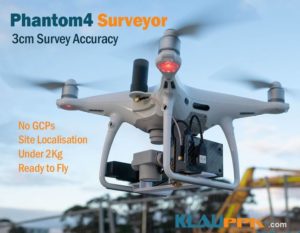
Klau Geomatics releases the ‘DJI Phantom4Pro Surveyor’ for accurate surveying and inspection without ground control points
Klau Geomatics, an Australian geospatial innovation company, announced today the KlauPPK enabled ‘DJI Phantom4Pro Surveyor’, a small drone for accurate surveying. This premium solution brings survey grade PPK direct geo-referencing accuracy to the under 2kg UAV class, offering a capable, accessible entry point for surveyors to embrace UAV technology. Surveyors ...

Australia’s largest geospatial solutions retailer brings the high precision KlauPPK module to the construction, mining and mapping industry.
Position Partners, Australia’s largest retailer of positioning and geospatial solutions for surveying, mining and civil construction, have partnered with Klau Geomatics to deliver technical training and support, improving the productivity and efficiency of accurate UAV surveying. Klau Geomatics, an innovative Australian technology company, produces the world’s most accurate and sophisticated PPK ...
Configure your Klau Geomatics system.
Contact us to discuss a system
for your requirements.