
As published in LiDAR News

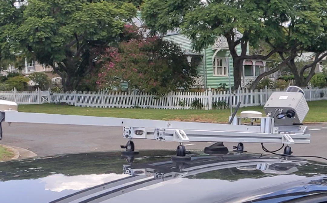
The Klau Geomatics Edge Compute ‘Brumby’ LiDAR generates live, accurate georeferenced point clouds. No post processing is required. The data is produced with geospatial coordinates at the speed of capture on the device. This groundbreaking tech makes LiDAR a fast, practical tool for asset management.
Capture is simple, results are ready.
The Data Logjam
LiDAR experts, analytics companies, app developers and online services create powerful intel at scale with massive data, in order to derive incredible value from billions of points in space.
BUT, producing highly accurate georeferenced point clouds is time consuming and creates a bottleneck when inpushing data into workflows. Whether terrestrial, mobile, airborne, SLAM – whatever it is, there is work, and time, and cost involved to geo-reference the data, withreal-world coordinates. It is difficult to keep up.
The ability to derive processed data at a greater pace, at a larger scale, is restricted by the ability to supply the accurate geo-referenced data.
The Tech
Enter Klau Geomatics. With highly efficient Edge Compute, the Brumby LiDAR produces dense, accurate georeferenced point clouds on the fly.
The Brumby leverages the best of NovAtel SPAN INS technology and custom low-level firmware and hardware, to process point clouds live as the data streams in. Coordinate systems and precise geoids are applied real time to the INS trajectory, to then derive each LiDAR point.
-
RTK-survey grade accuracy
-
Coordinate systems and geoids applied
-
Drive or fly the site, the accurate point cloud is ready to go.
Whatever you need to do with point cloud data, get to it, don’t be bogged down in producing the accurate point cloud data. With the Brumby it’s already done.
Accuracy and Time are Critical
Geo-referencing is critical for analytics, as having absolute accuracy enables repeat captures to detect change over time.
Live RTK LIDAR does change the game. By producing XYZ spatial data with absolute accuracy opens the 4th dimension, time. Not only are you capturing the asset as it is right now, it has absolute accuracy, which means you can compare it to the scans from yesterday or tomorrow.
And the state of an asset right now, or the change that can be seen right now, is much more valuable than what it is on last week’s data.

What this all means
This opens a whole new approach to using point clouds as an asset management tool. In many use cases, such as surface extraction for mapping, or volume determination for mining, the customer just wants the processed data. Often the required outcome is simple, and repetitive.
-
Infrastructure surveys: Asset managers can now easily capture a stretch of road to find, measure and assess damaged guardrails, posts and potholes. They want a current snapshot, not last weeks after a world of processing. Close each shift with a capture, archive ‘state of play’. Is work being done to schedule?
-
Inventories; mines and quarries. Mine managers can capture a site and know the change in stockpiles and pits for audits on a weekly, daily or even hourly basis. On a drone or just drive by. Measure today’s volumes and reconcile materials.
-
Analytics workflows: capture plenty of current data to flow straight into your AI and algorithms. Assess vegetation encroachment, measure biomass… Has the vegetation been cleared from the power lines since the previous capture?
-
GIS capture for government agencies and corporates; simple and fast.
-
Airborne terrain and vegetation mapping, data ready to go.
-
Integrated data capture; on autonomous mine vehicles, with high absolute accuracy and immediate data access. Have trains and other public transport vehicles assess the state of infrastructure as they travel.
-
Defence applications: to capture a battlefield for remote assessment and immediately define precise targets.
The Brumby opens a new way of thinking about mobile LiDAR.
See the video of a recent capture here: https://youtu.be/TOXMMEq_JW0.
