
NEWS
-
Hear the latest from Klau Geomatics
-
Subscribe on the Contact page and we’ll keep you up to date
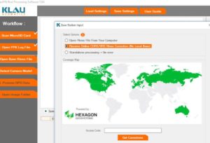
PPK with No Base Station
Klau Geomatics, industry leader in PPK direct georeferencing technology, announced today their new No-Base-Station high accuracy georeferencing solution for UAVs. This revolutionary new solution is the result of close collaboration between Klau Geomatics and Hexagon Geospatial Smartnet engineers that enables users to conduct UAV surveying projects without running a local ...
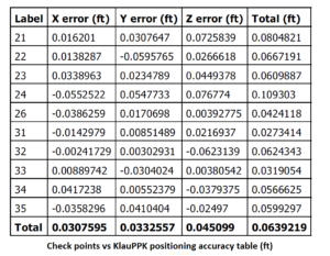
Stahly Engineering & Associates produce outstanding drone surveying accuracy with KlauPPK geo-referencing technology.
Another Klau Geomatics customer has successfully trialled the KlauPPK direct georeferencing system to achieve extremely high accuracy results with their DJI drone. Stahly Engineering (USA) has provided engineering services in the fields of transportation, site development, water and wastewater systems, and structures since 1970. They recently deployed the KlauPPK geo-positioning ...

Aerial Surveying Accuracy with UAVs
Achieving the best possible absolute accuracy, on the ground with UAVs and photogrammetry requires an understanding of a wide range of errors and how they propagate in the system. Aerial data capture is just that, aerial or remotely sensed, and it needs to be tied to the ground in some ...
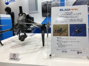
KlauGeomatics partners with Skylink to bring PPK positioning kits for DJI drones to Japan
Australian technology company KlauGeomatics has announced the launch of the KlauPPK kits in Japan with a partnership with Skylink to distribute to the Japanese surveying, engineering and construction markets. The KlauPPK technology enables users to create highly accurate, reliable and repeatable mapping data, without ground control points, transforming the capabilities ...
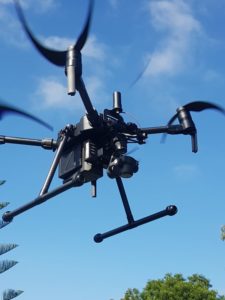
DJI M200/M210 PPK now available
Klau Geomatics, an Australian geospatial technology company, has announced a new PPK system for the DJI Matrice 200. With a similar installation on the Inspire 2, the system is proven to consistently achieve 3cm absolute accuracy in photogrammetry processing with no GCPs. Following the incredible results achieved with the Inspire ...
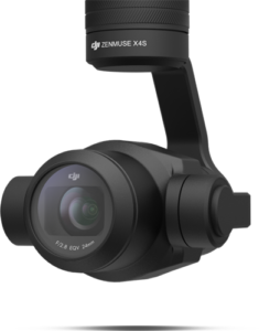
DJI’s Camera for Aerial Surveying
Do DJI know what they have with the X4s camera? This little power house of a camera is a light weight version of the large aerial cameras carried in manned aircraft. How do aerial or metric cameras differ to a DSLR? An aerial mapping camera is primarily designed to have ...
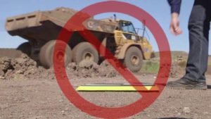
Turning any drone into an accurate mapping system without GCPs
UAV mapping projects require reliable, repeatable accuracy before they can be used and trusted by professional clients. The most common method of achieving this has been placing ground control points (GCPs) which must be spread across the entire site. Whether traditional surveyed targets or the various smart GCPs with built ...

4DMapper and Klau Geomatics introduce a game changing solution for accurate mapping and inspection
4DMapper has partnered with Klau Geomatics to offer an end-to-end solution for high accuracy mapping, with streamlined photogrammetry processing on Autodesk Forge, a cloud developer platform, delivering unmatched quality in 3D maps and models. 4DMapper, an established provider of cloud hosting and streaming services for geospatial data, has enabled this ...
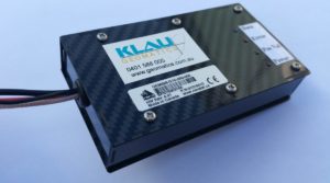
Turn your UAV into a precise mapping machine
Klau Geomatics, an innovative Australian technology company, enables UAV operators to produce highly accurate maps and models with its plug-and-play PPK positioning system. The system can be configured for most cameras and platforms, manned or UAV, with custom mounts and connectors for a simple installation. The PPK system has compact, ...

Klau Geomatics PPK brings precision mapping to DJI drones
Klau Geomatics, an innovative Australian technology company, has announced a new PPK system for the DJI Matrice100. Support for other DJI models will be added progressively in the near future. The DJI implementation continues from the success of the system in enabling a wide variety of manned aircraft and drones ...
Configure your Klau Geomatics system.
Contact us to discuss a system
for your requirements.